Boreholes
Boreholes are (always vertical) profiles, which represent a geological profile in specific coordinates.
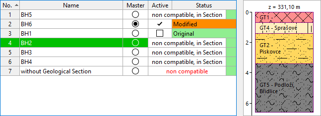
Boreholes can have various status (according to the way of creation):
- Original borehole - it is created automatically according to Soil profiles. Original boreholes cannot be deleted - they are always restored according to the original soil profile.
- Changed borehole - it is created by editing of Original borehole
- New borehole - it is created using "Add graphically" or "Add textually" buttons. It is used especially for the final modification of a 3D model.
One borehole must be selected as master borehole, which determines the number and order of soil layers in a geological model. Soil layers are displayed in the table of layers.
When modeling using geological sections, it is possible to create a 3D model with only one active master borehole.
The boreholes used in geological sections are implemented in already created interfaces - they are described as "incompatible, in Section".
The boreholes which are not used in geological sections and are not compatible (with the master borehole) are described as "incompatible" in red - these boreholes should be changed to compatible boreholes and this way used in modeling.

When generating only from the boreholes model, it is necessary to edit boreholes to be compatible with the master borehole. Incompatible boreholes are described as "not-compatible" in red and are not used in model generation. /
The model is generated only from active boreholes. Active boreholes must always be compatible with the master borehole.